


Size of this preview: 800 × 600 pixels. Other resolutions: 320 × 240 pixels | 640 × 480 pixels | 1,024 × 768 pixels | 1,280 × 960 pixels | 2,048 × 1,536 pixels.
Original file (2,048 × 1,536 pixels, file size: 2.16 MB, MIME type: image/jpeg)
Summary
| Description |
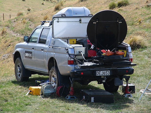
Deutsch: Mobile Erdfunkstelle des mobilen Landfunkdienstes über Satelliten genutzt durch einen TVNZ News-Reporter.
English: Land mobile earth station of the land mobile-satellite service, to send news over a satellite link used by TVNZ news reporters. The setup was made near firefighting operations, during the Mt Allan forest fire near Dunedin in New Zealand. |
| Date | Taken on 25 February 2010 |
| Source | Own work |
| Author | Benchill |
| Permission (Reusing this file) |
Own work, attribution required (Multi-license with GFDL and Creative Commons CC-BY 3.0) |
| Camera location | | View this and other nearby images on: OpenStreetMap |
|---|
Licensing
I, the copyright holder of this work, hereby publish it under the following licenses:

|
Permission is granted to copy, distribute and/or modify this document under the terms of the GNU Free Documentation License, Version 1.2 or any later version published by the Free Software Foundation; with no Invariant Sections, no Front-Cover Texts, and no Back-Cover Texts. A copy of the license is included in the section entitled GNU Free Documentation License. |
This file is licensed under the Creative Commons Attribution 3.0 Unported license.
- You are free:
- to share – to copy, distribute and transmit the work
- to remix – to adapt the work
- Under the following conditions:
- attribution – You must give appropriate credit, provide a link to the license, and indicate if changes were made. You may do so in any reasonable manner, but not in any way that suggests the licensor endorses you or your use.
You may select the license of your choice.
File history
Click on a date/time to view the file as it appeared at that time.
| Date/Time | Thumbnail | Dimensions | User | Comment | |
|---|---|---|---|---|---|
| current | 11:15, 25 February 2010 | | 2,048 × 1,536 (2.16 MB) | Benchill | {{Information |Description=One News satellite ute setup near firefighting operations, during the Mt Allan forest fire near Dunedin in New Zealand |Source=Own work by uploader |Date=2010-02-25 |Author=Benchill |Permission=Own work, attrib |
File usage
The following 4 pages use this file:
Global file usage
The following other wikis use this file:
- Usage on ar.wikipedia.org
- Usage on az.wikipedia.org
- Usage on de.wikipedia.org
- Usage on el.wikipedia.org
- Usage on es.wikipedia.org
- Usage on et.wikipedia.org
- Usage on id.wikipedia.org
- Usage on ja.wikipedia.org
- Usage on ru.wikipedia.org
- Usage on vi.wikipedia.org