


No higher resolution available.
CAMap-doton-EurekaValley.png (209 × 230 pixels, file size: 5 KB, MIME type: image/png)
Summary

|
This locator map image could be re-created using vector graphics as an SVG file. This has several advantages; see Commons:Media for cleanup for more information. If an SVG form of this image is available, please upload it and afterwards replace this template with
{{vector version available|new image name}}.
It is recommended to name the SVG file “CAMap-doton-EurekaValley.svg”—then the template Vector version available (or Vva) does not need the new image name parameter. |
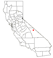
| Description |
English: Location of Eureka Valley (town and geographic valley)— within Inyo County, eastern California.
|
| Date | 5 June 2006 (original upload date) |
| Source | Transferred from en.wikipedia to Commons by Americophile. |
| Author | G. Thomas at English Wikipedia |
Licensing
| This work has been released into the public domain by its author, G. Thomas at English Wikipedia. This applies worldwide. In some countries this may not be legally possible; if so: G. Thomas grants anyone the right to use this work for any purpose, without any conditions, unless such conditions are required by law. |
Original upload log
The original description page was here. All following user names refer to en.wikipedia.
- 2006-06-05 22:28 G. Thomas 209×230× (4896 bytes) Location of Eureka Valley within California.
File history
Click on a date/time to view the file as it appeared at that time.
| Date/Time | Thumbnail | Dimensions | User | Comment | |
|---|---|---|---|---|---|
| current | 02:44, 24 April 2011 | | 209 × 230 (5 KB) | Mondephile | {{Information |Description={{en|Location of Eureka Valley within California.}} |Source=Transferred from [http://en.wikipedia.org en.wikipedia]; transfer was stated to be made by User:Razghandi. |Date={{Date|2006|06|05}} (original upload date) |Author= |
File usage
The following page uses this file:
Global file usage
The following other wikis use this file:
- Usage on fa.wikipedia.org
- Usage on fr.wikipedia.org