


Size of this PNG preview of this SVG file: 800 × 518 pixels. Other resolutions: 320 × 207 pixels | 640 × 414 pixels | 1,024 × 663 pixels | 1,280 × 829 pixels | 2,560 × 1,658 pixels | 1,464 × 948 pixels.
Original file (SVG file, nominally 1,464 × 948 pixels, file size: 3.42 MB)
Summary
| Description |
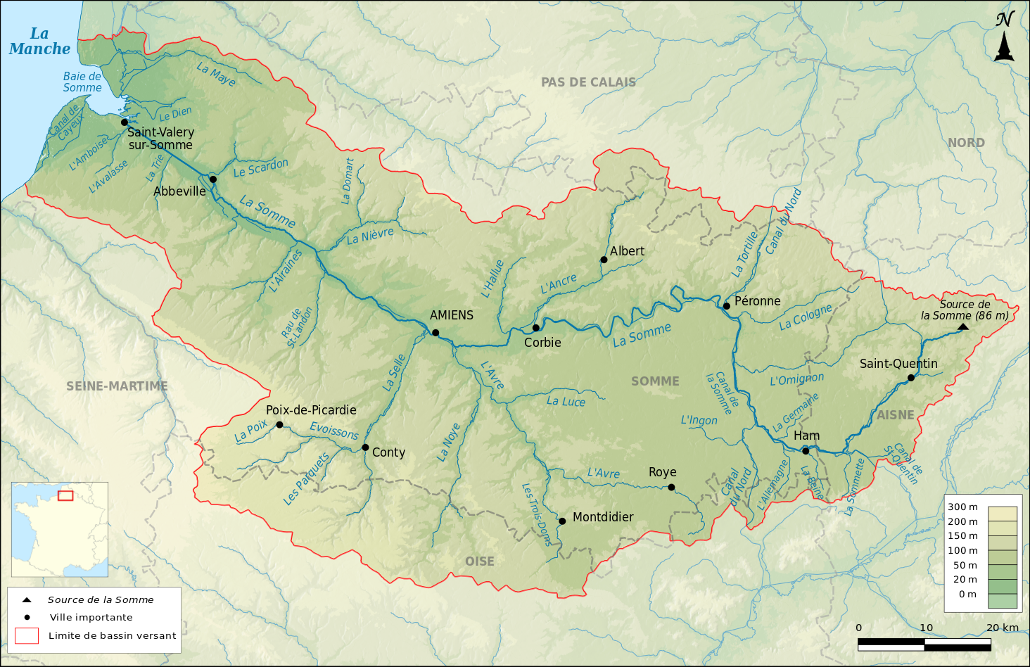
Français : Carte du bassin versant de la Somme |
| Date | |
| Source |
Own work Relief : SRTM3v2 Hydrographie : BD Carthage® Minicarte : Blank map of Europe par Historicair Projection : Lambert 93 |
| Author | Boldair |
Licensing
I, the copyright holder of this work, hereby publish it under the following license:
This file is licensed under the Creative Commons Attribution-Share Alike 4.0 International license.
- You are free:
- to share – to copy, distribute and transmit the work
- to remix – to adapt the work
- Under the following conditions:
- attribution – You must give appropriate credit, provide a link to the license, and indicate if changes were made. You may do so in any reasonable manner, but not in any way that suggests the licensor endorses you or your use.
- share alike – If you remix, transform, or build upon the material, you must distribute your contributions under the same or compatible license as the original.
File history
Click on a date/time to view the file as it appeared at that time.
| Date/Time | Thumbnail | Dimensions | User | Comment | |
|---|---|---|---|---|---|
| current | 20:07, 12 January 2016 | | 1,464 × 948 (3.42 MB) | Boldair | L'amboise |
| 16:22, 10 January 2016 |  | 1,464 × 948 (3.41 MB) | Boldair | modifs | |
| 16:13, 10 January 2016 |  | 1,464 × 948 (3.41 MB) | Boldair | modifs | |
| 16:26, 3 January 2016 |  | 1,464 × 948 (3.41 MB) | Boldair | ajout de détails | |
| 21:47, 2 January 2016 |  | 1,464 × 948 (3.41 MB) | Boldair | Rectifications toponymiques | |
| 09:23, 2 January 2016 |  | 1,464 × 948 (3.41 MB) | Boldair | ajouts de villes et rivières | |
| 17:18, 1 January 2016 |  | 1,464 × 948 (3.4 MB) | Boldair | Ajout canal de la Somme | |
| 16:46, 1 January 2016 |  | 1,464 × 948 (3.4 MB) | Boldair | ajout de villes | |
| 16:37, 1 January 2016 |  | 1,464 × 948 (3.39 MB) | Boldair | rectifs | |
| 16:30, 1 January 2016 |  | 1,464 × 948 (3.39 MB) | Boldair | Rectifications |
File usage
The following 18 pages use this file:
- Attack on the Gommecourt Salient
- Battle of Abbeville
- Battle of Albert (1916)
- Battle of Bazentin Ridge
- Battle of Delville Wood
- Battle of Hébuterne
- Battle of the Somme
- British Expeditionary Force (World War II)
- Capture of Contalmaison
- Capture of Ovillers
- First day on the Somme
- Operation Cycle
- Operation Jericho
- Somme (river)
- Somme towns
- XIX Army Corps
- Talk:First Battle of Dernancourt
- User talk:Keith-264/sandbox4
Global file usage
The following other wikis use this file:
- Usage on bg.wikipedia.org
- Usage on cs.wikipedia.org
- Usage on de.wikipedia.org
- Usage on el.wikipedia.org
- Usage on es.wikipedia.org
- Usage on fi.wikipedia.org
- Usage on fr.wikipedia.org
- Abbeville
- Somme (fleuve)
- Bataille de Crécy
- Montdidier (Somme)
- Péronne (Somme)
- Noye
- Saint-Valery-sur-Somme
- Bataille de la Somme
- Ham (Somme)
- Canal du Nord (France)
- Conty
- Poix-de-Picardie
- Roye (Somme)
- Canal de Saint-Quentin
- Canal de la Somme
- Utilisateur:Boldair
- Scardon
- Selle (affluent de la Somme)
- Omignon
- Hallue
- Ancre (rivière)
- Nièvre (affluent de la Somme)
- Avre (affluent de la Somme)
- Luce (rivière)
- Trois Doms
- Dien (rivière)
- Cologne (rivière)
- Airaines (rivière)
- Liste des affluents et sous-affluents de la Somme
- Modèle:Palette Affluents de la Somme
- Amboise (rivière)
- Évoissons
- Saint-Landon
- Sommette (rivière)
- Tortille
- Brache (affluent de l'Avre)
- Germaine (affluent de la Somme)
- Trie (rivière)
- Ingon
- Beine (rivière)
- Liste des cours d'eau de la Somme
View more global usage of this file.


