


Matanuska-Susitna Borough, Alaska
Matanuska-Susitna Borough, Alaska | |
|---|---|
 | |
 Flag  Seal | |
 Location within the U.S. state of Alaska | |
| Coordinates: 62°24′N 149°35′W / 62.4°N 149.58°W | |
| Country | |
| State | |
| Incorporated | January 1, 1964[1][2] |
| Named after | Matanuska River and Susitna River |
| Seat | Palmer |
| Largest CDP | Knik-Fairview |
| Government | |
| • Borough Mayor | Edna DeVries |
| Area | |
• Total | 25,258 sq mi (65,420 km2) |
| • Land | 24,608 sq mi (63,730 km2) |
| • Water | 650 sq mi (1,700 km2) 2.6% |
| Population | |
• Total | 107,081 |
• Estimate (2024) | 117,613 |
| • Density | 4.3515/sq mi (1.6801/km2) |
| Time zone | UTC−9 (Alaska) |
| • Summer (DST) | UTC−8 (ADT) |
| Congressional district | At-large |
| Website | www |
Matanuska-Susitna Borough (often referred to as the Mat-Su Borough) is a borough located in the U.S. state of Alaska. Its borough seat is Palmer, and the largest incorporated community is Wasilla. As of the 2020 census, the borough's population was 107,081.[3]
The borough is part of the Anchorage Metropolitan Statistical Area, along with the municipality of Anchorage on its south.
The Mat-Su Borough is designated as so because it contains the entire Matanuska and Susitna Rivers. They empty into Cook Inlet, which is the southern border of the Mat-Su Borough. It is one of the few agricultural areas in Alaska.
Geography

As of the 2020 census, the population was 107,081, up from 88,995 in 2010. It is the fastest growing subdivision in Alaska.[4]
According to the United States Census Bureau, the borough has a total area of 25,258 square miles (65,420 km2), of which 24,608 square miles (63,730 km2) is land and 650 square miles (1,700 km2) (2.6%) is water.[5]
Adjacent boroughs and census areas
- Denali Borough, Alaska - north
- Southeast Fairbanks Census Area, Alaska - northeast
- Copper River Census Area, Alaska - east
- Chugach Census Area, Alaska - south
- Municipality of Anchorage, Alaska - south
- Kenai Peninsula Borough, Alaska - south
- Bethel Census Area, Alaska - west
- Yukon-Koyukuk Census Area, Alaska - west
National protected areas in the borough
- Chugach National Forest (part)
- Denali National Park and Preserve (part)
- Denali Wilderness (part)
- Lake Clark National Park and Preserve (part)
- Lake Clark Wilderness (part)
Demographics
| Census | Pop. | Note | %± |
|---|---|---|---|
| 1960 | 5,188 | — | |
| 1970 | 6,509 | 25.5% | |
| 1980 | 17,816 | 173.7% | |
| 1990 | 39,683 | 122.7% | |
| 2000 | 59,322 | 49.5% | |
| 2010 | 88,995 | 50.0% | |
| 2020 | 107,081 | 20.3% | |
| 2024 (est.) | 117,613 | [6] | 9.8% |
| U.S. Decennial Census[7] 1790–1960[8] 1900–1990[9] 1990–2000[10] 2010–2020[3] | |||
2020 census
As of the 2020 census, the borough had a population of 107,081. The median age was 36.3 years. 27.1% of residents were under the age of 18 and 13.3% of residents were 65 years of age or older. For every 100 females there were 107.1 males, and for every 100 females age 18 and over there were 106.8 males age 18 and over.[11]
The racial makeup of the borough was 77.5% White, 1.0% Black or African American, 6.4% American Indian and Alaska Native, 1.5% Asian, 0.5% Native Hawaiian and Pacific Islander, 1.6% from some other race, and 11.5% from two or more races. Hispanic or Latino residents of any race comprised 4.9% of the population.[12]
49.9% of residents lived in urban areas, while 50.1% lived in rural areas.[13]
There were 38,380 households in the borough, of which 35.4% had children under the age of 18 living with them and 19.2% had a female householder with no spouse or partner present. About 23.2% of all households were made up of individuals and 8.3% had someone living alone who was 65 years of age or older.[11]
There were 51,077 housing units, of which 24.9% were vacant. Among occupied housing units, 75.6% were owner-occupied and 24.4% were renter-occupied. The homeowner vacancy rate was 2.3% and the rental vacancy rate was 10.0%.[11]
2000 census
As of the 2000 census, there were 59,322 people, 20,556 households, and 15,046 families residing in the borough. The population density was 2 people per square mile (0.77 people/km2). There were 27,329 housing units at an average density of 1 per square mile (0.39/km2). The racial makeup of the borough was 87.55% White, 0.69% Black or African American, 5.50% Native American, 0.70% Asian, 0.12% Pacific Islander, 0.86% from other races, and 4.57% from two or more races. 2.50% of the population were Hispanic or Latino of any race.[14]
There were 20,556 households, out of which 42.30% had children under the age of 18 living with them, 58.90% were married couples living together, 9.10% had a female householder with no husband present, and 26.80% were non-families. 20.30% of all households were made up of individuals, and 4.10% had someone living alone who was 65 years of age or older. The average household size was 2.84 and the average family size was 3.29.
In the borough the population was spread out, with 32.20% under the age of 18, 7.40% from 18 to 24, 31.10% from 25 to 44, 23.40% from 45 to 64, and 5.90% who were 65 years of age or older. The median age was 34 years. For every 100 females, there were 108.20 males. For every 100 females age 18 and over, there were 108.10 males.
Schools in the borough are administered by the Matanuska-Susitna Borough School District.
Politics and government

| Year | Republican | Democratic | Third party(ies) | |||
|---|---|---|---|---|---|---|
| № | % | № | % | № | % | |
| 1960 | 1,152 | 52.20% | 1,055 | 47.80% | 0 | 0.00% |
| 1964 | 964 | 43.72% | 1,241 | 56.28% | 0 | 0.00% |
| 1968 | 1,076 | 46.42% | 892 | 38.48% | 350 | 15.10% |
| 1972 | 2,004 | 66.62% | 694 | 23.07% | 310 | 10.31% |
| 1976 | 2,884 | 60.70% | 1,485 | 31.26% | 382 | 8.04% |
| 1980 | 5,012 | 61.36% | 1,316 | 16.11% | 1,840 | 22.53% |
| 1984 | 9,944 | 73.69% | 2,940 | 21.79% | 610 | 4.52% |
| 1988 | 8,856 | 65.01% | 4,172 | 30.63% | 594 | 4.36% |
| 1992 | 7,564 | 39.13% | 4,379 | 22.66% | 7,385 | 38.21% |
| 1996 | 11,306 | 59.81% | 4,522 | 23.92% | 3,074 | 16.26% |
| 2000 | 17,976 | 69.31% | 5,379 | 20.74% | 2,579 | 9.94% |
| 2004 | 17,569 | 72.71% | 6,201 | 25.66% | 394 | 1.63% |
| 2008 | 30,246 | 74.50% | 9,297 | 22.90% | 1,056 | 2.60% |
| 2012 | 27,339 | 72.68% | 9,317 | 24.77% | 959 | 2.55% |
| 2016 | 31,947 | 74.39% | 8,598 | 20.02% | 2,398 | 5.58% |
| 2020 | 38,492 | 71.90% | 12,849 | 24.00% | 2,195 | 4.10% |
| 2024 | 40,140 | 72.50% | 13,343 | 24.10% | 1,882 | 3.40% |
Republicans have carried the Matanuska-Susitna borough in every election except for 1964.[16] Though the borough has aligned with the statewide presidential election winner in Alaska in every election since statehood, it has come to stand out as one of the most Republican areas in Alaska, alongside the neighboring, less populated Southeast Fairbanks Census Area. In 2020, around 20% of Donald Trump's vote share in the state came from this borough alone. Downballot, Matanuska-Susitna Borough has voted for Republican governors all but a handful of times.
Edna DeVries is the mayor of the Matanuska-Susitna Borough. The borough has a strong-manager form of government. Mike Brown is the borough manager. Long-time Manager John Duffy retired in 2010.[17]
Sarah Palin was previously the mayor of Wasilla, the largest city in the borough.
Communities
Cities
Census-designated places
- Big Lake
- Buffalo Soapstone
- Butte
- Chase
- Chickaloon
- Eureka Roadhouse
- Farm Loop
- Fishhook
- Gateway
- Glacier View
- Knik River
- Knik-Fairview
- Lake Louise
- Lazy Mountain
- Meadow Lakes
- North Lakes
- Petersville
- Point MacKenzie
- Skwentna
- South Lakes
- Susitna
- Susitna North
- Sutton-Alpine
- Talkeetna
- Tanaina
- Trapper Creek
- Willow
Unincorporated community
Cyber attack
In July 2018, the borough's computer systems, including the library and animal shelter, were hit by a ransomware attack, forcing employees to do without computers, using electric typewriters where available.[18] The borough declared a state of emergency[19] and incurred over $2 million in costs.[20] The method is thought to have been a targeted phishing e-mail; data left by the malware indicated Mat-Su was the 210th target attacked.[21]
Education
The school district is Matanuska-Susitna Borough School District.[22]
Gallery

See also
- Matanuska-Susitna Valley
- List of Airports in the Matanuska-Susitna Borough
- Matanuska Formation
- Deshka Landing Fire
References
- ^ "History". Matanuska-Susitna Borough Joint Land Use Study. 2009. Archived from the original on March 6, 2012. Retrieved May 4, 2012.
- ^ 1996 Alaska Municipal Officials Directory. Juneau: Alaska Municipal League/Alaska Department of Community and Regional Affairs. January 1996. p. 12.
- ^ a b c "State & County QuickFacts". United States Census Bureau. Retrieved June 3, 2025.
- ^ "2020 Census Data - Cities and Census Designated Places" (Web). State of Alaska, Department of Labor and Workforce Development. Retrieved October 31, 2021.
- ^ "US Gazetteer files: 2010, 2000, and 1990". United States Census Bureau. February 12, 2011. Retrieved April 23, 2011.
- ^ "County Population Totals and Components of Change: 2020-2024". United States Census Bureau. Retrieved June 3, 2025.
- ^ "U.S. Decennial Census". United States Census Bureau. Retrieved October 31, 2021.
- ^ "Historical Census Browser". University of Virginia Library. Retrieved May 17, 2014.
- ^ "Population of Counties by Decennial Census: 1900 to 1990". United States Census Bureau. Retrieved May 17, 2014.
- ^ "Census 2000 PHC-T-4. Ranking Tables for Counties: 1990 and 2000" (PDF). United States Census Bureau. Archived (PDF) from the original on October 9, 2022. Retrieved May 17, 2014.
- ^ a b c "2020 Decennial Census Demographic Profile (DP1)". United States Census Bureau. 2021. Retrieved December 21, 2025.
- ^ "2020 Decennial Census Redistricting Data (Public Law 94-171)". United States Census Bureau. 2021. Retrieved December 21, 2025.
- ^ "2020 Decennial Census Demographic and Housing Characteristics (DHC)". United States Census Bureau. 2023. Retrieved December 21, 2025.
- ^ "U.S. Census website". United States Census Bureau. Retrieved January 31, 2008.
- ^ Elections, RRH. "RRH Elections". rrhelections.com. Retrieved January 12, 2020.
- ^ "Alaska Results by County Equivalent, 1960-2020". April 13, 2021.
- ^ Matanuska-Susitna Borough. Matsugov.us. Retrieved on August 2, 2013.
- ^ "Town dusts off typewriters after cyber-attack". BBC News. August 1, 2018.
- ^ Leroy Polk; Beth Verge (August 2, 2018) [August 1, 2018]. "'This is not somebody in his mother's basement': Massive cyberattack prompts Mat-Su disaster declaration". KTUU.
- ^ Zaz Hollander (October 12, 2018) [October 11, 2018]. "Price tag for cyberattack on Mat-Su Borough now tops $2 million". Anchorage Daily News.
- ^ Chris Baraniuk (January 9, 2019). "In Depth: The cyber-attack that sent an Alaskan community back in time". BBC News.
- ^ "2020 CENSUS - SCHOOL DISTRICT REFERENCE MAP: Matanuska-Susitna Borough, AK" (PDF). U.S. Census Bureau. Retrieved December 21, 2024. - Text list
External links
- [1] official government website
- [2] Borough Facebook
- [3] Borough newsroom
- Borough map, 2000 census: Alaska Department of Labor
- Borough map, 2010 census: Alaska Department of Labor
Places adjacent to Matanuska-Susitna Borough, Alaska | ||||||||||||||||
|---|---|---|---|---|---|---|---|---|---|---|---|---|---|---|---|---|
| ||||||||||||||||
Municipalities and communities of Matanuska-Susitna Borough, Alaska, United States | ||
|---|---|---|
| Cities | 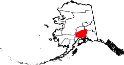 | |
| CDPs |
| |
| Former CDPs | ||
| Unincorporated communities |
| |

62°24′N 149°35′W / 62.40°N 149.58°W
| International | |
|---|---|
| National | |
| Other | |