


File:DST Countries Map.png
Size of this preview: 800 × 355 pixels. Other resolutions: 320 × 142 pixels | 640 × 284 pixels | 1,024 × 454 pixels | 1,280 × 568 pixels | 2,560 × 1,136 pixels | 4,952 × 2,197 pixels.
Original file (4,952 × 2,197 pixels, file size: 463 KB, MIME type: image/png)
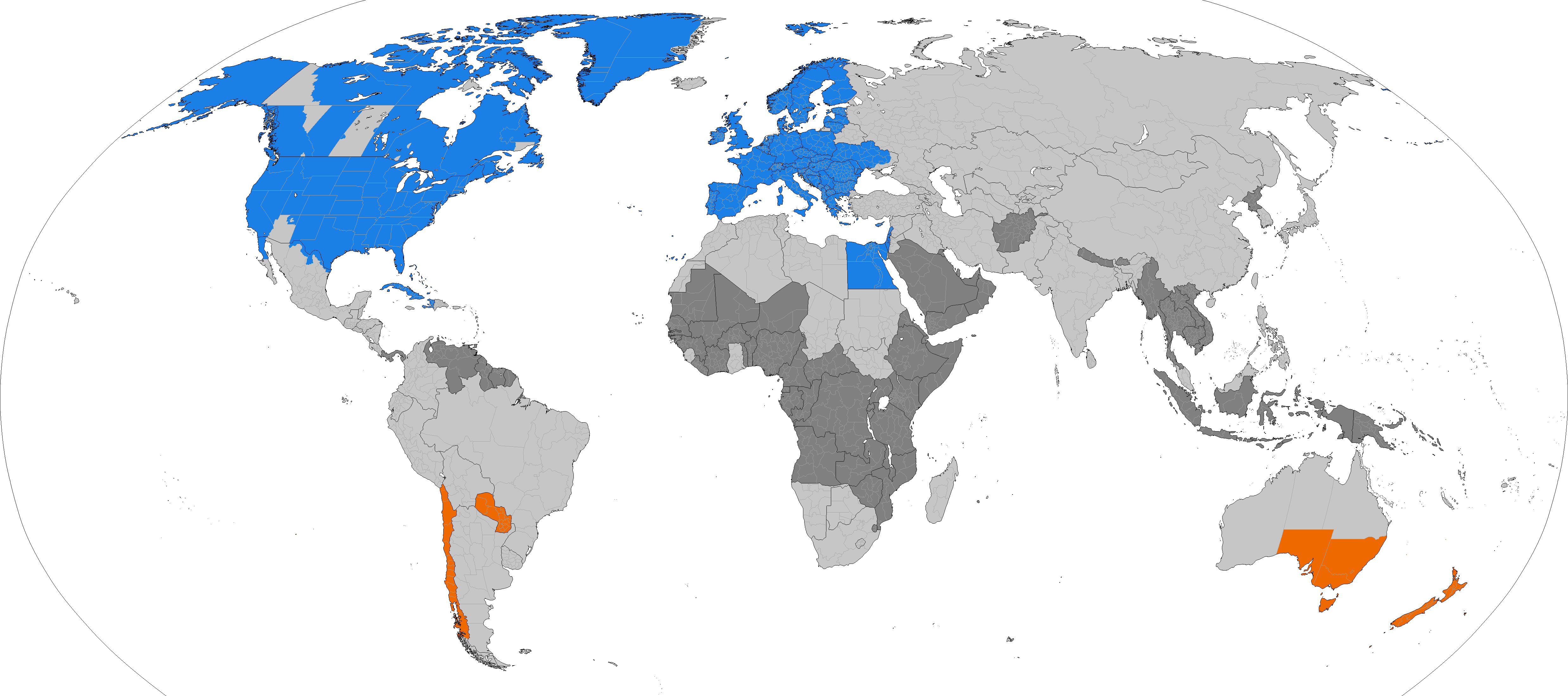
Dark grey places have never used daylight savings, light grey places formerly used it. Orange places use daylight savings in the southern hemisphere summer. Blue places use daylight savings in the northern hemisphere summer.
| This file may be updated to reflect new information. If you wish to use a specific version of the file without it being overwritten, please upload the required version as a separate file. |

|
This map of the world image could be re-created using vector graphics as an SVG file. This has several advantages; see Commons:Media for cleanup for more information. If an SVG form of this image is available, please upload it and afterwards replace this template with
{{vector version available|new image name}}.It is recommended to name the SVG file “DST Countries Map.svg”—then the template Vector version available (or Vva) does not need the new image name parameter. |
Summary
| Description |
English: Larger map of the previous version. Distinguished from summertime in the northern hemisphere and southern hemisphere.
Northern hemisphere summer
Southern hemisphere summer
Formerly used daylight savings
Never used daylight savings Bahasa Indonesia: Peta yang lebih besar dari versi sebelumnya. Membedakan masa musim panas di belahan bumi utara dan selatan.
Musim panas belahan bumi utara
Musim panas belahan bumi utara
Menggunakan waktu musim panas di masa lampau
Tidak pernah menggunakan waktu musim panas |
| Date | |
| Source | Own work |
| Author | TimeZonesBoy |
| Other versions |
Supplementary map: |

Licensing
I, the copyright holder of this work, hereby publish it under the following license:
This file is licensed under the Creative Commons Attribution-Share Alike 3.0 Unported license.
- You are free:
- to share – to copy, distribute and transmit the work
- to remix – to adapt the work
- Under the following conditions:
- attribution – You must give appropriate credit, provide a link to the license, and indicate if changes were made. You may do so in any reasonable manner, but not in any way that suggests the licensor endorses you or your use.
- share alike – If you remix, transform, or build upon the material, you must distribute your contributions under the same or compatible license as the original.
File history
Click on a date/time to view the file as it appeared at that time.
| Date/Time | Thumbnail | Dimensions | User | Comment | |
|---|---|---|---|---|---|
| current | 19:23, 8 March 2026 | | 4,952 × 2,197 (463 KB) | Heitordp | Corrected southeast British Columbia, adjusted colors, reduced file size |
| 10:59, 8 March 2026 |  | 4,952 × 2,197 (711 KB) | Ratherous | British Columbia | |
| 07:07, 17 February 2026 |  | 4,952 × 2,197 (458 KB) | Tcfc2349 | fixed | |
| 15:09, 22 December 2025 |  | 4,952 × 2,197 (487 KB) | NormandMapping | Complied to leave all black borders intact; reintegrated previous subdivision fixes; fixed Bhutan (the north has been occupied by China since before it abolished its DST); added Mymensingh Division to Bangladesh; fixed more miscoloured pixels in Turkey and Tunisia. | |
| 19:16, 20 December 2025 |  | 4,952 × 2,197 (451 KB) | M.Bitton | Reverted to version as of 00:52, 4 December 2025 (UTC): per WP:COMOVERWRITE you shoudn't fiddle with the borders (tou removed the one bwteen Morocco and Western Sahara) | |
| 10:50, 20 December 2025 |  | 4,952 × 2,197 (487 KB) | NormandMapping | Fixed miscoloured pixels in the Gambia, Guinea-Bissau, Nigeria, Indonesia. Updated Indonesian subdivisions (split Papua). Fixed French Guiana to be region-level like the rest of France. Marked more disputed borders (South America, Korean DMZ [the solution used in CIA World Factbook maps], Kosovo [consistent with other limited-recognition states; keeping the UNMIK districts], Western Sahara [reflecting UN Resolution 2797, de facto supporting the Morocco autonomy plan]). | |
| 19:37, 17 December 2025 |  | 4,952 × 2,197 (487 KB) | NormandMapping | Subdivision fixes• Added Lubusz to Poland. • Added Kyiv City to Ukraine. • Added a proper border between Viciebsk and Hrodna in Belarus. • Added a proper border between Borsod–Abaúj–Zemplén and Nógrád in Northern Hungary. • Fixed the Emilia-Romagna southern border in Italy. • Adjusted Shida Kartli de jure borders in Georgia. • Adjusted Prizren district borders in Kosovo. • Merged a nonexistent Egyptian governorate into Red Sea Governorate. Territorial disputes • Cleaned up and updated de fac... | |
| 00:52, 4 December 2025 |  | 4,952 × 2,197 (451 KB) | Tcfc2349 | fixed | |
| 22:41, 14 November 2025 |  | 4,952 × 2,197 (710 KB) | American Angel1 | Fixed Borders of Donetsk Oblast and Put Lands in Donetsk and Zaporizhzhia Oblasts as no longer Using Daylight Savings Time(DST) | |
| 00:34, 24 March 2025 |  | 4,952 × 2,197 (462 KB) | Heitordp | Updated Chile |
File usage
The following 4 pages use this file:
Global file usage
The following other wikis use this file:
- Usage on ar.wikipedia.org
- Usage on azb.wikipedia.org
- Usage on bs.wikipedia.org
- Usage on ckb.wikipedia.org
- Usage on es.wikipedia.org
- Usage on fa.wikipedia.org
- Usage on ga.wikipedia.org
- Usage on hu.wikipedia.org
- Usage on hy.wikipedia.org
- Usage on ja.wikipedia.org
- Usage on la.wikipedia.org
- Usage on lo.wikipedia.org
- Usage on lt.wikipedia.org
- Usage on ne.wikipedia.org
- Usage on pnb.wikipedia.org
- Usage on ru.wikipedia.org
- Usage on sd.wikipedia.org
- Usage on sh.wikipedia.org
- Usage on simple.wikipedia.org
- Usage on sq.wikipedia.org
- Usage on sr.wikipedia.org
- Usage on ta.wikipedia.org
- Usage on th.wikipedia.org
- Usage on tr.wikipedia.org
- Usage on vi.wikipedia.org
- Usage on zh.wikipedia.org