


File:Mackenzie Large Igneous Province.png
No higher resolution available.
Mackenzie_Large_Igneous_Province.png (550 × 485 pixels, file size: 255 KB, MIME type: image/png)

|
This geology image could be re-created using vector graphics as an SVG file. This has several advantages; see Commons:Media for cleanup for more information. If an SVG form of this image is available, please upload it and afterwards replace this template with
{{vector version available|new image name}}.It is recommended to name the SVG file “Mackenzie Large Igneous Province.svg”—then the template Vector version available (or Vva) does not need the new image name parameter. |
Summary
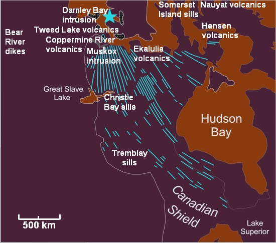
| Description |
English: Map of the Mackenzie Large Igneous Province and location of associated volcanic zones. |
| Date | |
| Source | Own work based on MLIP map information from [1] |
| Author | Black Tusk |
Licensing
I, the copyright holder of this work, hereby publish it under the following license:
This file is licensed under the Creative Commons Attribution 3.0 Unported license.
- You are free:
- to share – to copy, distribute and transmit the work
- to remix – to adapt the work
- Under the following conditions:
- attribution – You must give appropriate credit, provide a link to the license, and indicate if changes were made. You may do so in any reasonable manner, but not in any way that suggests the licensor endorses you or your use.
File history
Click on a date/time to view the file as it appeared at that time.
| Date/Time | Thumbnail | Dimensions | User | Comment | |
|---|---|---|---|---|---|
| current | 06:48, 28 December 2009 | | 550 × 485 (255 KB) | Black Tusk | fixing spelling error: Damley Bay --> Darnley Bay |
| 05:09, 28 December 2009 |  | 550 × 485 (255 KB) | Black Tusk | {{Information |Description={{en|1=Map of the Mackenzie Large Igneous Province and location of associated volcanic zones.}} |Source={{own}} based on MLIP map information from [http://www.largeigneousprovinces.org/08sep.html] |Author=[[User:Black Tusk|Black |
File usage
The following 4 pages use this file:
Global file usage
The following other wikis use this file:
- Usage on es.wikipedia.org
- Usage on it.wikipedia.org
- Usage on simple.wikipedia.org
- Usage on www.wikidata.org