


File:ShepardMap802Northumbria.png

Size of this preview: 467 × 599 pixels. Other resolutions: 187 × 240 pixels | 374 × 480 pixels | 650 × 834 pixels.
Original file (650 × 834 pixels, file size: 359 KB, MIME type: image/png)
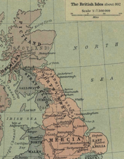
A detail from William Shepherd's map of the British Isles about 802 AD, showing the kingdom of Northumbria and neighboring domains. Mapa de William Shepherd de las Islas Britanicas alrededor de 802, se muestra los reinos de Northumbria, Bernicia, Deira, y otros
source: http://www.lib.utexas.edu/maps/historical/shepherd/british_isles_802.jpg
.jpg)
This work is in the public domain because it was published in the United States between 1931 and 1963, and although there may or may not have been a copyright notice, the copyright was not renewed. For further explanation, see Commons:Hirtle chart and the copyright renewal logs.
|
 |
File history
Click on a date/time to view the file as it appeared at that time.
| Date/Time | Thumbnail | Dimensions | User | Comment | |
|---|---|---|---|---|---|
| current | 02:18, 1 August 2016 | | 650 × 834 (359 KB) | JohnnyMrNinja | compression and file indexing |
| 04:16, 5 June 2006 |  | 650 × 834 (1.02 MB) | Mijotoba | A detail from William Shepherd's map of the British Isles about 802 AD, showing the kingdom of Northumbria and neighboring domains. Mapa de William Shepherd de las Islas Britanicas alrededor de 802, se muestra los reinos de Northumbria, Bernicia, Deira, y |
File usage
The following page uses this file:
Global file usage
The following other wikis use this file:
- Usage on ast.wikipedia.org
- Usage on br.wikipedia.org
- Usage on es.wikipedia.org
- Usage on gl.wikipedia.org
- Usage on pt.wikipedia.org
- Usage on sr.wikipedia.org