


Spišské Podhradie
Spišské Podhradie | |
|---|---|
 View of Spišské Podhradie from the Spiš Castle | |
 Flag  Coat of arms | |
 Spišské Podhradie Location of Spišské Podhradie in the Prešov Region  Spišské Podhradie Location of Spišské Podhradie in Slovakia | |
| Coordinates: 49°00′N 20°45′E / 49.00°N 20.75°E | |
| Country | |
| Region | |
| District | Levoča District |
| First mentioned | 1249 |
| Government | |
| • Mayor | MVDr. Michal Kapusta |
| Area | |
• Total | 24.94 km2 (9.63 sq mi) |
| Elevation | 448 m (1,470 ft) |
| Population | |
• Total | 3,730 |
| Time zone | UTC+1 (CET) |
| • Summer (DST) | UTC+2 (CEST) |
| Postal code | 530 4[3] |
| Area code | +421 53[3] |
| Vehicle registration plate (until 2022) | LE |
| Website | www |
Spišské Podhradie (German: Kirchdrauf, Hungarian: Szepesváralja) is a town in Spiš in the Prešov Region of Slovakia. Its population is 3,775.
Spišské Podhradie is situated at the foot of the hill of Spiš Castle. It had a Zipser German settlement, with its own church and priest, in 1174. Just above, and adjacent to, the town is the ecclesiastical settlement of Spišská Kapitula (hence an old German name Kirchdorf, meaning "church town"). The town contains a number of Renaissance merchants' houses. It also has one of the few remaining synagogue buildings (now disused) in the region. The Sivá Brada cold water spring is located nearby.
Geography
The municipality lies at an altitude of 448 metres (1,470 ft)[3] and covers an area of 24.94 km2 (9.63 sq mi) (2024).[4]
Population
| Year | 1994 | 2004 | 2014 | 2024 |
|---|---|---|---|---|
| Count | 3665 | 3872 | 4035 | 3730 |
| Difference | +5.64% | +4.20% | −7.55% |
| Year | 2023 | 2024 |
|---|---|---|
| Count | 3754 | 3730 |
| Difference | −0.63% |
It has a population of 3730 people (31 December 2024).[6]
Ethnicity
| Ethnicity | Number | Fraction |
|---|---|---|
| Slovak | 3425 | 90.34% |
| Romani | 363 | 9.57% |
| Not found out | 232 | 6.11% |
| Rusyn | 51 | 1.34% |
| Total | 3791 |
In year 2021 was 3791 people by ethnicity 3425 as Slovak, 363 as Romani, 232 as Not found out, 51 as Rusyn, 12 as Czech, 5 as Chinese, 5 as Hungarian, 4 as Polish, 4 as German, 2 as Russian, 2 as Other, 1 as Irish, 1 as Canadian and 1 as Albanian.
Note on population The difference between the population numbers above and in the census (here and below) is that the population numbers above are mostly made up of permanent residents, etc.; and the census should indicate the place where people actually mainly live.
For example, a student is a citizen of a village because he has permanent residence there (he lived there as a child and has parents), but most of the time he studies at a university in the city.
Religion
| Religion | Number | Fraction |
|---|---|---|
| Roman Catholic Church | 2823 | 74.47% |
| None | 390 | 10.29% |
| Not found out | 329 | 8.68% |
| Greek Catholic Church | 122 | 3.22% |
| Evangelical Church | 41 | 1.08% |
| Christian Congregations in Slovakia | 39 | 1.03% |
| Total | 3791 |
In year 2021 was 3791 people by religion 2823 from Roman Catholic Church, 390 from None, 329 from Not found out, 122 from Greek Catholic Church, 41 from Evangelical Church, 39 from Christian Congregations in Slovakia, 10 from Other, 10 from Ad hoc movements, 5 from Eastern Orthodox Church, 4 from Calvinist Church, 3 from Other and not ascertained christian church, 3 from Islam, 3 from Apostolic Church, 2 from Jehovah's Witnesses, 2 from Czechoslovak Hussite Church, 1 from Hinduism, 1 from United Methodist Church, 1 from Seventh-day Adventist Church, 1 from Church of Jesus Christ of Latter-day Saints and 1 from Buddhism.
Twin towns — sister cities
Spišské Podhradie is twinned with:
 Głogów Małopolski, Poland
 Pinetop-Lakeside, Arizona, United States
- Show Low, Arizona, United States
 Vrbové, Slovakia
Dreveník
Dreveník is a mesa-shaped travertine mound in the Hornád Basin and a national nature reserve.[10] It is located on the border of the districts of Spišská Nová Ves and Levoča. This area, with an area of 1,018,186 m², has been protected since 1925. Together with the nearby Spiš Castle, it has been included in the World Heritage Site of UNESCO since 1993.[11][12][13] It is also the largest travertine massif in Slovakia.[14]
Gallery
-
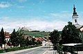
 Road in Spišská Kapitula with Spiš Castle above
 -
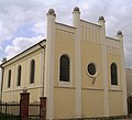 Synagogue at Spišské Podhradie
 -
 Town center and Spiš Castle above
 -
 View of Spišské Podhradie and Spiš Castle in the background
 -
 A street in Spišské Podhradie


.jpg)

References
- ^ "Hustota obyvateľstva - obce [om7014rr_obc=AREAS_SK, v_om7014rr_ukaz=Rozloha (Štvorcový meter)]". Statistical Office of the Slovak Republic. 2025-03-31. Retrieved 2025-03-31.
- ^ "Počet obyvateľov podľa pohlavia - obce (ročne) [om7101rr_obce=AREAS_SK]". Statistical Office of the Slovak Republic. 2025-03-31. Retrieved 2025-03-31.
- ^ a b c d "Základná charakteristika". www.statistics.sk (in Slovak). Statistical Office of the Slovak Republic. 2015-04-17. Retrieved 2022-03-31.
- ^ "Hustota obyvateľstva - obce [om7014rr_obc=AREAS_SK, v_om7014rr_ukaz=Rozloha (Štvorcový meter)]". Statistical Office of the Slovak Republic. 2025-03-31. Retrieved 2025-03-31.
- ^ a b "Počet obyvateľov podľa pohlavia - obce (ročne) [om7101rr_obce=AREAS_SK]". Statistical Office of the Slovak Republic. 2025-03-31. Retrieved 2025-03-31.
- ^ "Počet obyvateľov podľa pohlavia - obce (ročne) [om7101rr_obce=AREAS_SK]". Statistical Office of the Slovak Republic. 2025-03-31. Retrieved 2025-03-31.
- ^ "Population - Basic results". www.scitanie.sk. Statistical Office of the Slovak republic. Retrieved 2025-11-03.
- ^ "Population - Basic results". www.scitanie.sk. Statistical Office of the Slovak republic. Retrieved 2025-11-03.
- ^ "Population - Basic results". www.scitanie.sk. Statistical Office of the Slovak republic. Retrieved 2025-11-03.
- ^ "Dreveník: Zoznam osobitne chránených častí prírody SR". data.sopsr.sk. Banská Bystrica: Štátna ochrana prírody SR.
- ^ "Law Protected Plants Of National Nature Reserve Dreveník (Hornád Basin) In Project Learning". www.actahort.org. Retrieved 2026-01-05.
- ^ Administrátor (2024-06-15). "Skalné mesto Kamenný raj". Spoznaj Slovensko (in Slovak). Retrieved 2026-01-06.
- ^ "Dreveník chráni Slovensko už 100 rokov. Z unikátu mohol byť kameňolom, dnes je klenotom európskej siete". ta3.sk.
- ^ a.s, Petit Press. "Raj pre turistov aj lezcov. Pozrite si krásnu jar na Dreveníku". Korzár Spiš-Gemer (in Slovak). Retrieved 2026-01-08.
External links
| International | |
|---|---|
| National | |
| Geographic | |
| Other | |