


St. Marks, Kansas
St. Marks, Kansas | |
|---|---|
 St. Mark Catholic Church (2012) | |
 | |
 St. Marks  St. Marks | |
| Coordinates: 37°44′9″N 97°33′44″W / 37.73583°N 97.56222°W[1] | |
| Country | United States |
| State | Kansas |
| County | Sedgwick |
| Townships | Union, Attica |
| Area | |
• Total | 0.98 sq mi (2.54 km2) |
| • Land | 0.98 sq mi (2.53 km2) |
| • Water | 0.0039 sq mi (0.01 km2) |
| Elevation | 1,434 ft (437 m) |
| Population | |
• Total | 124 |
| • Density | 127/sq mi (49.0/km2) |
| Time zone | UTC-6 (CST) |
| • Summer (DST) | UTC-5 (CDT) |
| ZIP code | 67030 (Colwich) |
| Area code | 316 |
| FIPS code | 20-62375 [1] |
| GNIS ID | 474003 [1] |
St. Marks is an unincorporated community and census-designated place (CDP) in Sedgwick County, Kansas, United States.[1] As of the 2020 census, the population was 124.[3] It is located about 4 miles (6 km) southwest of Colwich along "W 29th St N" between "N 183rd St W" and "N 199th St W", also it is located 5 miles (8 km) north of Goddard.
History
The community is based around the St. Mark Catholic Church that was built in c.1903-1906.
The first post office in Saint Marks was established February, 1879. the postal service was discontinued in December, 1903. [4]
Demographics
| Census | Pop. | Note | %± |
|---|---|---|---|
| 2020 | 124 | — | |
| U.S. Decennial Census | |||
Education
The community is served by Renwick USD 267 public school district.[5] St. Marks School (K-8) is located in St. Marks at 19001 W. 29th St. N.
References
- ^ a b c d e "St. Marks, Kansas", Geographic Names Information System, United States Geological Survey, United States Department of the Interior
- ^ "2020 U.S. Gazetteer Files – Kansas". United States Census Bureau. Retrieved May 12, 2021.
- ^ a b "Profile of St. Marks, Kansas (CDP) in 2020". United States Census Bureau. Archived from the original on November 14, 2021. Retrieved November 14, 2021.
- ^ "National Register Information System". National Register of Historic Places. National Park Service. July 9, 2010.
- ^ Geography Division (January 15, 2021). 2020 Census - School District Reference Map: Sedgwick County, KS (PDF) (Map). U.S. Census Bureau. Retrieved November 5, 2025. - Text list
Further reading
External links
Municipalities and communities of Sedgwick County, Kansas, United States | ||
|---|---|---|
| Cities | 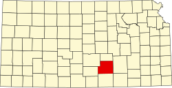 | |
| CDPs | ||
| Unincorporated communities | ||
| Townships | ||
| Footnotes | ‡This community also has portions in an adjacent county or counties. | |