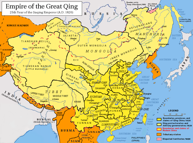
Размер этого предпросмотра: 800 × 593 пкс. Другие разрешения: 320 × 237 пкс | 640 × 475 пкс | 910 × 675 пкс.
Исходный файл (910 × 675 пкс, размер файла: 398 КБ, MIME-тип: image/png)
История файла
Нажмите на дату/время, чтобы посмотреть файл, который был загружен в тот момент.
| Дата/время | Миниатюра | Размеры | Участник | Примечание | |
|---|---|---|---|---|---|
| текущий | 05:15, 17 мая 2014 |  | 910 × 675 (398 КБ) | Tenohira | fix |
| 04:32, 17 мая 2014 |  | 910 × 675 (401 КБ) | Benlisquare | rev: per the guideline page at Commons:Overwriting existing files, you should be creating a fork file, not overwriting this existing one | |
| 00:48, 17 мая 2014 |  | 910 × 675 (394 КБ) | Tenohira | remove "nine-dotted line" https://en.wikipedia.org/wiki/File_talk:Qing_Dynasty_1820.png | |
| 23:59, 16 мая 2014 |  | 910 × 675 (372 КБ) | Tenohira | original | |
| 21:52, 19 декабря 2012 |  | 910 × 675 (401 КБ) | Pryaltonian~commonswiki | Adjusted map to be more in line with contemporary-Qing maps, with references also from late-Qing and Republican China. | |
| 15:35, 22 сентября 2011 |  | 910 × 675 (380 КБ) | Pryaltonian~commonswiki | Only southern Palawan was part of the Borneo and then Sulu sultanates, until Spanish annexation of Sulu in 1851. | |
| 15:10, 21 сентября 2011 |  | 910 × 675 (380 КБ) | Pryaltonian~commonswiki | Modified to distinguish between provinces, military governorates, and protectorates. Tributary states also added. | |
| 03:48, 22 июня 2010 |  | 910 × 675 (355 КБ) | Benlisquare | Revert - redraw the map yourself. MS Paint overlaying of a corner is an eyesore. Illogical to have the title repeated twice. | |
| 21:46, 21 июня 2010 |  | 910 × 675 (386 КБ) | Hisacw | rv to NPOVify: the status on certain outlier islands (e.g. Sakhalin) is not explicitly defined, c.f. the map [http://go-passport.grolier.com/map?id=mh00032&pid=go] | |
| 05:59, 20 июня 2010 |  | 910 × 675 (355 КБ) | Benlisquare | Reverted to version as of 19:58, 27 September 2008 |
Использование файла
Следующие 6 страниц используют этот файл:
Глобальное использование файла
Данный файл используется в следующих вики:
- Использование в als.wikipedia.org
- Использование в an.wikipedia.org
- Использование в ar.wikipedia.org
- Использование в arz.wikipedia.org
- Использование в azb.wikipedia.org
- Использование в az.wikipedia.org
- Использование в bat-smg.wikipedia.org
- Использование в ba.wikipedia.org
- Использование в be-tarask.wikipedia.org
- Использование в be.wikipedia.org
- Использование в bg.wikipedia.org
- Использование в cs.wikipedia.org
- Использование в da.wikipedia.org
- Использование в de.wikipedia.org
- Использование в en.wikipedia.org
- Qing dynasty
- History of Taiwan
- Inner Mongolia
- Administrative divisions of China
- Zhili
- Talk:History of the administrative divisions of China before 1912
- Tannu Uriankhai
- User:Pryaltonian
- Portal:Taiwan
- Taiwan under Qing rule
- User:Eumolpus214
- Talk:Qing dynasty/Archive 3
- History of Tuva
- Senkaku Islands dispute
- Tributary system of China
- Talk:Chinese civilization/Archive 26
- Talk:Qing dynasty/Archive 5
- Qing dynasty in Inner Asia
- Timeline of the Qing dynasty
- Timeline of Yunnan-Guizhou
- Talk:History of Xinjiang/Archive 1
- Administration of territory in dynastic China
- Government of the Qing dynasty
- User:SilverStar54/Administrative divisions of China
- Wikipedia:Reference desk/Archives/Humanities/2023 July 15
- User:Falcaorib/China
- Administrative divisions of the Qing dynasty
- Использование в es.wikipedia.org
Просмотреть глобальное использование этого файла.


